Accurate BIM ready Survey Models
3D Survey Models
3D Modelling Surveys
Accurate & Detailed 3D BIM Models
Begin your project on the right foot with an accurate 3D Modelling Survey from our expert in-house team. Our comprehensive models are designed to match your project’s specific requirements, ensuring the correct criteria and level of detail. By choosing our 3D model services, you minimise on-site disruption through our efficient and unobtrusive survey methods.
Our precise and realistic 3D models enable early detection of clashes and issues between existing site conditions and your design, leading to reduced project costs and timelines. They also serve as an excellent base for visualisations, facilitating clear communication with clients, contractors, and stakeholders. Additionally, our 3D survey models help your project comply with BIM Level 2 standards from the outset.
We provide models in Autodesk® Revit® and IFC formats, with options for 3D AutoCAD®, renders, and video walkthroughs to meet all your project needs.
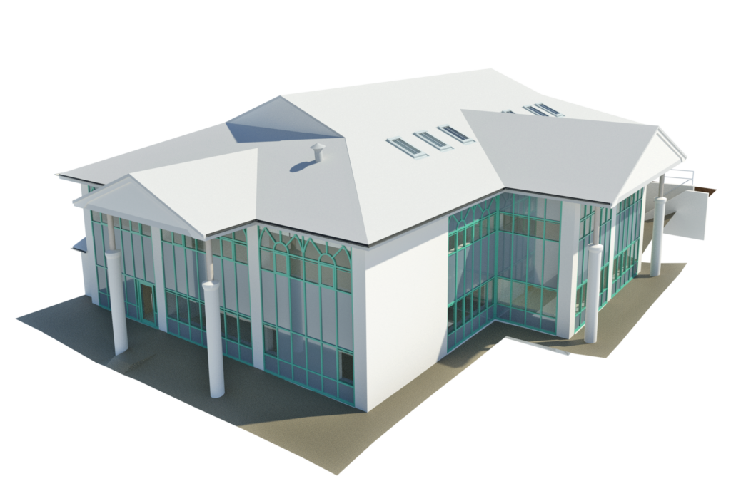
Accurate & Detailed 3D BIM Models
Begin your project on the right foot with an accurate 3D Modelling Survey from our expert in-house team. Our comprehensive models are designed to match your project’s specific requirements, ensuring the correct criteria and level of detail. By choosing our 3D model services, you minimise on-site disruption through our efficient and unobtrusive survey methods.
Our precise and realistic 3D models enable early detection of clashes and issues between existing site conditions and your design, leading to reduced project costs and timelines. They also serve as an excellent base for visualisations, facilitating clear communication with clients, contractors, and stakeholders. Additionally, our 3D survey models help your project comply with BIM Level 2 standards from the outset.
We provide models in Autodesk® Revit® and IFC formats, with options for 3D AutoCAD®, renders, and video walkthroughs to meet all your project needs. View our video portfolio here.
Our 3D Survey Model Services
Tailored Solutions for Every Project


3D Service Models
3D services, whether above or below ground, are detected by our surveyors using a number of methods. We then convert these findings into a 3D model for you to use within your project. These are particularly useful for clash detection on busy sites.
More Details >

2D to 3D Conversion
Existing 2D drawings are converted into accurate 3D Revit models. Additional survey data may be required to complete the process, which our own survey teams can provide.
Engineering drawings are converted into a 3D Revit model for spatial coordination with other consultants.
More Details >
3D Building Modelling
We create models of existing buildings that can be used for design development, presentation purposes, and as a foundation for working drawings. Our level of detail (LOD) is customisable to suit your project, ensuring you get exactly what you need.
High levels of details are often needed for listed elements and high level retrofit or refurbishment. Lower levels are best for strip-outs or basic remodelling works.
We can tailor our survey to suit your project requirements , for example picking out key elements to a higher level of detail, identifying certain fixed furnishings or MEP, or focusing on the structural elements in particular.
More Details


Considerations for Building Models
Specific elements may require a different level of detail due to listing status or refurbishment requirements. We can tailor these sections accordingly.
3D Site Models
Laser Surveys can model the existing site topography in Revit for easy integration with other consultants’ BIM models.
Often, 3D building models are combined with site models to provide comprehensive context, including surrounding buildings, features, and even solar studies for light analysis.
We can tailor site models to your project requirements, for example if particular features need a higher level of detail, certain key site components need identifying or even if you require us to run a solar study of the site. Just get in touch with your requirements and we can do the rest.
More Details


Considerations for Site Models
Different parts of the site can be modelled to varying levels of detail. Trees and bushes are generic within the model, with height and position based on topographical data.
3D Services Models
Our team specialises in detecting and modelling above and below-ground services, creating either 3D AutoCAD drawings or Revit models for your project. Laser scanning is used for accessible services, with models derived from the resulting point cloud data.
3D service models are particularly useful for clash detection and can be combined with topographical and building models to provide a comprehensive site overview.
We do not identify which services the pipework holds in laser scanned projects and will represent all pipe– and duct-work as a generic type.


2D to 3D Conversion
Converting Your 2D Drawings to 3D BIM Models has never been easier!
Our team can convert your existing 2D drawings into 3D Revit models for improved spatial coordination with other consultants. If additional data is required, our survey teams can conduct further surveys to ensure the model meets your needs. Engineering drawings are carefully transformed into accurate and detailed BIM models.