What is a Topographical Survey?
A topographical survey, often referred to as a “topo survey” or “land survey”, is a detailed and accurate representation of the natural and man-made features on a specific piece of land. It includes the land’s contours, elevations, and physical features such as trees, buildings, roads, and rivers. The primary goal is to provide a clear and precise map or plan that shows the terrain and any significant features within a designated area. The survey can be provided in various forms, from hardcopy paper plans, to 2D CAD drawings and 3D digital models.
What is the Purpose of a Topographical Survey?
The purpose of a topographical survey is to accurately map and document the physical features and terrain of a piece of land. This detailed information serves multiple critical functions across various industries and projects. Primarily, it aids in planning and design by helping architects and engineers create structures and infrastructure that fit seamlessly within the land’s natural features, ensuring stability and safety. In construction, topographic surveys assist in site preparation by identifying the best locations for foundations and drainage systems and help in calculating the amount of earth that needs to be moved, optimising costs and timelines. For land development, these surveys inform urban planning and landscaping, ensuring efficient use of space and resources. They also play a crucial role in environmental management by assessing the impact of proposed developments on the natural environment and aiding in the creation of mitigation strategies. Legally, topo surveys are essential for defining property boundaries accurately, which is crucial for legal documentation and resolving boundary disputes. Additionally, they are valuable for infrastructure maintenance, helping manage utilities and plan repairs for existing roadways and infrastructure. In essence, a topographical survey provides a accurate and detailed map of a land area, detailing its natural and man-made features, which is invaluable for ensuring that projects are safe, efficient, and environmentally friendly.

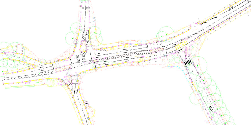
What Information is Captured?
The detail captured during a land survey can be tailored to the specific needs of each project, but in most cases will include:
- Site Boundaries
- Buildings and structures
- Street furniture and overhead cables
- Trees, bushes, and vegetation positions
- Ground levels, contours, and surfaces
- Manhole and Inspection Covers
- Eaves and Ridge Heights (on site/adjacent if required)
- Road markings
What Equipment is Used?
Survey companies employ a range of survey equipment for topographical surveys depending on the site and requirements. Traditional data capture involves a tripod mounted total station and GPS instrumentation. Laser scanners offer rapid data collection and can excel in areas with hard detail, while drone surveys efficiently capture vast amounts of data, particularly in open areas. Traditional survey methods, such as total stations, are recommended for overgrown or foliage-rich environments.
What are the key benefits?
How long does the survey take?
The time taken to complete a topographical survey can be dependent upon several factors, primarily the size of the site and the level of detail required. Open rural sites can be efficiently surveyed, due to their expansive and unobstructed nature. On the other hand, intricate built-up sites may require a more a more controlled approach which can extend the survey duration.
What deliverables are available?
Topographical surveys can be delivered in a range of formats depending on project requirements. 2D and 3D CAD formats are the most widely used. However, 3D Models can be provided in several formats enhancing the compatibility with Building Information Modelling (BIM) processes.
Ready to Get Started? Explore Our Services and Request a Quote!
At Laser Surveys Limited, we are committed to providing survey data of the highest quality for a competitive fee. Whether you’re ready to request a quote or interested in exploring our range of services, we invite you to take the next step.